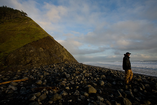
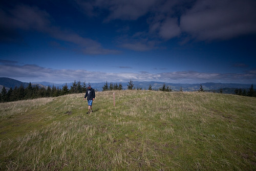
I've been real quiet in blog-land, but I finally got out on another adventure; this time back to The Lost Coast. This year I decided to just do a portion of the trail so that I could explore some of the ridges above the beach, and so that I wouldn't have to pay for the shuttle (which is reasonable if you must do the whole 25.5 miles, but still $200 is a bit expensive). I got a hold of my nephew Josh and he readily agreed to accompany me on a few night stay.
Wednesday I got off work early, met up with Josh and headed to REI for some last minute pick ups (namely he needed a bear canister) before heading out on the long drive to Mattole beach. We made pretty good time to Garberville (that place can be a whole story in and of itself....Weird place!), but just then the "light rain" that was forecasted hit us and we had to drive through a constant downpour for much of the long winding road to the coast which took a few hours. I had planned to stay one night at A.W. Way state park campground, but we figured if we're going to get dumped on it might as well be at the trailhead, so we pushed on to the beach.
Surprisingly, once we pulled up the rained stopped and we had plenty of time to set up our tents, drink a six-pack of beer(Eel River Brew Co. Porter), and explore the beach a bit in the moonlight before heading off to bed. Seemingly minutes after retiring to bed it started to pour again. Timing is everything.
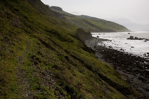
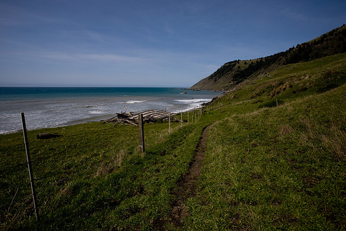
The next morning the rain magnificently had stopped again, and we made a quick breakfast and packed up for the hike in to Cooskie Creek. Last year we had eagerly headed straight for the water to start the hike, but this year I knew better and stuck up high by the hillsides finding large sections of bluff trails that were so much easier to walk on. So quickly was our progress on these trails, that I was amazed to see the lighthouse come into view just as we reached the private cabins at four-mile creek (which funny enough is only about 3 miles in...Somebody sure liked to exaggerate). A nice thick log provided a perfect bridge for our first major creek crossing which went smoothly.
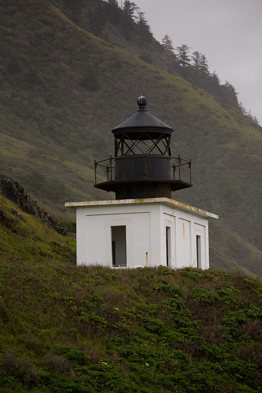
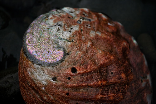
At the Punta Gorda Lighthouse we took our packs off and explored the tide pools a bit, as we had arrived at close to low tide (this is particularly important for the next few miles of the trail). The weather was great as we spied on lounging seals, and discovered all kinds of neat things in the pools and about.
As we returned to the sheltered lighthouse the rains came on and proceeded to pour. It was kind of surreal to watch out at all the rain while cooking and eating a hot lunch in the dry shelter. Once again fortune smiled upon us, as just when we started to pack up the rains stopped again.
For a good couple of miles the weather was fair, and at one point I started to lather up in sunblock as the sun dared to show itself. It was at about this time that I marveled at how fortunate we were and the gods decided to show me who is boss. I had just about enough time to put away my camera, put my pack cover on, and get out my light rain jacket before it started to rain on us. It was not real heavy, but certainly not a sprinkle either. I do have to admit, I rather enjoyed the shower. In the back of my mind I was a little worried that we'd get dumped on all weekend though.
Before long we had hammered out all 6.8 miles to camp (man it sure felt easier this year). The whole way in I had envisioned us staying in this large drift wood shelter on the north side of the creek, but to my amazement the entire thing was gone when we arrived. A smaller piling of drift wood had replaced it a bit further from the creek (which I suspect wiped out the prior one), but we decided to cross over to the south side and stay where I had set up camp last year.
This crossing was a bit more dicey than the one at four-mile creek. There was a very thin (and very wet) log up river a ways where the current was really moving, or rock hopping down by the waves that were still pretty far receded from the tide. I opted for the log, Josh opted for the later. In the end we both crossed dryly and met at our camp for the next two nights.
We enjoyed another clearing in the rain to set up camp and check out the area. Unfortunately a campsite just back from us was littered with camping gear that was apparently abandoned by whomever had inhabited it. I couldn't believe all the crap they hauled out there and left. There was a collapse 4-man tent (Some Wal-Mart brand), two burner stove with a full canister of propane (they must not have stayed long), a big rectangular Coleman sleeping bag, a thick car camping sleeping pad (more of a mattress), a dog leash, and bits of food and food wrappers all around. I was disgusted by what I saw, and took photos of everything and I sent them to the local ranger after we got back. I was relieved to hear back from him stating that he's planning a trip in the next week or so with an empty pack to recover the mess. I hope he gets a volunteer or two to help drag all of that out (if I was local I certainly would lend a hand).
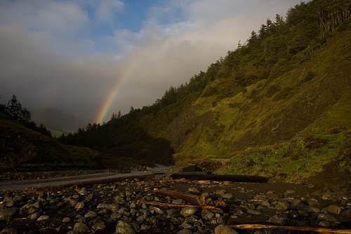
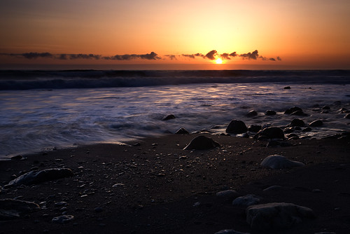
Anyways, after consolidating the mess a bit, I put that behind me and returned to enjoy our camp. The rains came back for an hour or so, which had me holed up in the tent for a bit listening to music and hanging my socks to dry. At 4:00 or 5:00 the rain was heading out, so I enjoyed a hot meal hunched up by the wood shelter (wearing my flip flops of course...I'll never go camping without them again!). By the time I had finished eating it had cleared for good and we were presented with a double rainbow as a peace offering from the gods. The light was fantastic and the sunset most memorable!
We drank vodka and Gatorade mixes with an occasional pull off of Josh's flask full of Johnny Walker, and worked hard to get a fire going in the wet conditions. We tried about everything, tissues, white fuel from my stove, but it continued to fizzle out. Finally Josh pulled out his propane stove and held it to our bundle of wet kindling until it dried enough to stay ignited. It still took a good half an hour to forty-five minutes before we had a decent size fire, but it was so worth it.
The next morning I awoke early and enjoyed the first light of the day with a hot cup of Starbucks Via coffee. That stuff is really good; perfect for backpacking! From a hill behind our tents I sat and watched spout after spout shoot up from near the horizon and could even occasionally see a whale breach. To top it off the sky was blue and it promised to be a beautiful day.
After a long slumber Josh awoke and we packed up for the day. Our plan was to head up river and catch the Cooskie Creek ridge trail that was eight tenths of a mile up. We planned to then head up to the ridges to the south leaving the ridges to the north to explore the next day with the packs. That is until we began to realize how hard going it is bush whacking up this creek. It took us well over an hour to make our way up, and we decided then and there that we would not be taking the packs up this way the next day. Perhaps when the water level is lower it would be easy going, but after all the rain of the last few days it was flowing pretty good. We climbed steep hills covered with poison oak (mostly following animal trails that dead ended), hugged rock croppings along the waters edge, and trudged through the mud of a whole hillside that was sliding towards the river.
At one point I was holding what I thought was a big stable rock while I maneuvered around a corner only to have it come loose and pull me right off the ledge and into the creek. Luckily I landed on my feet and my expensive camera gear was spared the bath. Quite a start to an eleven mile hike we had planned for the day (most of which would be with wet socks/boots).
Once we found the trail I washed the mud off my boots and hung my socks to dry as much as they could (the sun was being stubborn and hiding behind clouds). I had an interesting backpacker meal of Tofu Pesto Pasta, and pumped enough water for us to get up and over the ridge.
It was nice to get on an established trail, but this was not designed as a hiking trail. The path is an old 4WD jeep trail leftover from when this area was not a protected wilderness. It was super steep and unforgiving without a single switchback that I could count. The views were nothing short of spectacular though, and I was motivated to keep moving knowing that we had to cover 4 miles up the ridge before hitting the trail junction that goes 3 miles back down to the beach all the while gaining 2400 feet and losing it all. To add to the sense of urgency we estimated that we needed to get down to Randall Creek on the beach by 5PM so that we'd have enough time to make the remaining 2 miles back to camp before the tide came in (that part of the trail is impassible at high tides). This would sure be a good test of my knees!
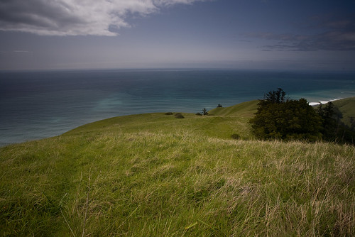
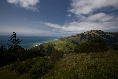
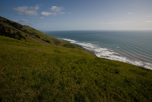
I was amazed at how good of time we made making it up to the first ridge at about 1,200 feet. The ocean below was spectacularly beautiful, juxtaposed beneath the steep green hills we were hiking upon. The ridge we would come down looked so far away though, we were only at half the elevation and it was already after 2:00. We pushed on keeping up a good pace, stopping once in awhile to take in the majestic views and snap a photo or two.
By 3:30 we had reached the summit and the junction of the Cooskie Creek Trail and the Spanish Ridge Trail that we would be taking down. Words can't describe very well how breath taking the view was, and my photos pale compared to my memory of it. The tide was coming though, and we had an hour and a half to descend 2,400 feet on a steep 3 mile trail.
Shortly after the peace, the solitude, the quiet beauty of our surroundings were shattered by two dirt bikes approaching quickly. They knew they were breaking the law, and I glared at them harshly as they flew by us; both of them gunning it as they passed to throw up debris probably in an attempt to keep me from photographing them. I reported the time and location of their activities, but I wish I had fired off some photos to get something to identify them. Who knows though, out there miles from anything I might have gotten myself run down if I had attempted it. Jerks like that absolutely disgust me.
Soon after all that was left of them was they track they had cut into the trail and the hillside. The views soon took over, and I was too busy enjoying myself to think of them any further. That's about when I heard an odd sound coming from a dark forest that we had approached off a side trail that cuts northwest towards Randall Creek. Three deep toned primal sounding hoo sounds. I called to Josh and asked him to listen. Again, "hoo hoo hoo" hit my ears clear as day. Josh heard nothing. Thoughts of Sasquatch, skunk apes, big foot or what have you crossed my mind. This is after all the Humboldt Coast which mythically is home to such creatures.
I later talked to a Ranger who had a much more logical explanation that I can buy. He says these parts are home to owls that can have a particularly deep tone. Still, it is kind of fun to think "what if".
Diving into the woods to get a photograph of Big Foot would have to wait. We have a high tide to beat to get back to camp. We continued down what I can only describe as the steepest "trail" I have ever been on. Surprisingly I held up rather well though with only a bit of a burn in my knees. Josh, who makes a living hiking up and down hills with the Forestry said even his knees were hurting, so that's to be expected. Within an hour we were a stones throw from the shoreline, crouching down to get some photos of a few poppies that had popped up.

At 5 o' clock on the nose we crossed Randall Creek and headed north through the tidal zone. We still have plenty of room to get by, but we could see in places where it would have been tough if we had waited any further.
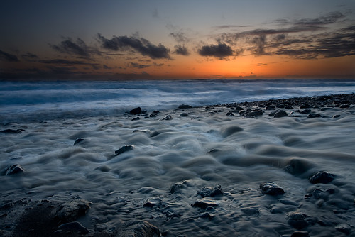
Once at camp I had my favorite backpacker meal (lasagna!), we drank lots of spirits and enjoyed the sunset before starting a roaring fire with the drift wood that had dried out all day. So comfortable were we by the fire sipping Whiskey and smoking a cigar that before we knew it, it was midnight. What a fabulous day!
The next morning we were pretty beat from the long hike and decided to pass on exploring the northern part of the Cooskie Creek Trail (another 2400 foot climb just didn't sound fun anymore). Besides, we had to move our camp further north and we would be stuck until after lunch waiting for the high tide to go out.
By the time we hit the trail we made great time moving north. So much, that as we passed Sea Lion Gulch and the Lighthouse we decided to just keep on moving and head all the way out. Another storm was set to come in over night, and the thought of getting all wet again just to pack up in the morning and leave was not too appealing.
By 5:00 we had covered the whole 6.8 miles, changed into some clean clothes, and dunked our heads into the cold water from the spigot (people passing by in full on jackets seemed somewhat amused).
All that was left was the long drive home.
See what was in my pack here: http://www.flickr.com/photos/januaryphotography/4448610795/in/set-72157623614577555/
Full set of photos can be found here: http://www.flickr.com/photos/januaryphotography/sets/72157623614577555/
GPS data is posted on EveryTrail here:
Lost Coast March 2010 at EveryTrail
Map your trip with EveryTrail
Be sure to check out my Lost Coast Trip from last year: http://alwaysjanuary.blogspot.com/search/label/Lost%20Coast%20Trail
BTW, clicking on any photo on this page will give you a slightly larger view (on black of course), and any word that is a different color is a link to a photograph.
6 comments:
absolutely fabulous photos
Thank you :-)
Wow... That shot of sunset (above the paragraph abt drinking gatorade mixes) is AMAZING. Totally gallery-wrap worthy!
Cool stuff! I will defiantly have to reconsider another coast camp this summer, I will be sure to keep this area in mind and your trail is also in Google Earth with everytrail. Those photos are amazing! My complements to the photographer!
Great blog and trip reports.
Now that you have hiked both the entire stretch of trail along the beach and explored some of the side trails and ridges, is there a route that you prefer? I'm headed out there in May to hike for 4 days and three nights and can't decide which part to hike.
The motion never stops in our cellular Live Casino with games obtainable to play 24/7 with a 메리트카지노 devoted helpline to offer you comprehensive support if you need it. Download the app at present and you’ll ready to|be succesful of|have the ability to} entry our full range of options and games wherever you go. Browse our intensive on line casino games record to discover a game that’s simply right for you. Whether you’re a slot enthusiast on the hunt for a mega jackpot, or an old-school gambler who loves taking on the home, there’s one thing for everyone at Wildz Casino.
Post a Comment