Being a father of two young children, I don't often get the chance to get out and be adventurous. So when the opportunity presented itself when my wife planned a trip for 12 days to visit friends and family with the kids, I jumped on it and started planning a trip as wild as I could come up with. I knew I wanted to go backpacking, but the prospect of camping in the snow wasn't as appealing as it once was when I was a crazy youth. Thus, I thought about exploring somewhere near the coast. What better coast in California than the Lost Coast. So I got a hold of my buddy Rob and talked him into joining me on a 25 mile journey down one of the only remaining stretches of pristine coast line in the country. Below is day one of our trip. I'll be adding the rest over the next few days.
Day 1, The journey begins:
The day before I had left work early and picked up Rob at the airport along the way. We had a pretty uneventful ride in that included a much too long meal at Garberville's interpretation of Mexican food that caused us to arrive at Nadelos campground well after dark. Surprisingly the campground was completely empty so we set up under the headlights of my truck and got to bed early.
The next morning we got up early and broke camp fast before heading off to pick up my bear canister and get into Shelter Cove to pick up some breakfast before catching our ride to the trail head. Someone from Sherri's shuttle service arrived right on time to pick us up from the Black Sands parking lot, and we headed off down the long winding road to Mattole Beach where the trail begins.
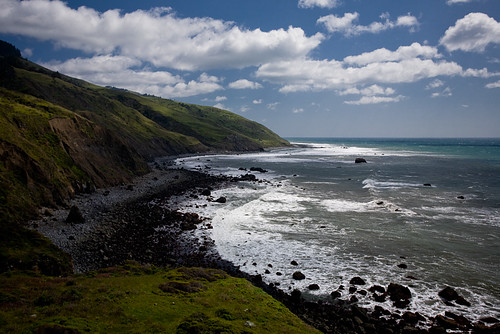
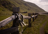
As we headed off down the sandy trail the wind was blowing hard and cold. We spent the entire first day in full thermals and sweaters seldom looking back towards the north where the wind was howling from. It didn't take long to realize that hiking with full packs in the soft sand was even more difficult that we had imagined. The sand would give way to rocks, that turned to boulders, and occasionally we were blessed with nice firm dirt paths on the bluffs above the beach.
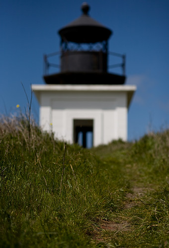
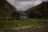
After a couple of hours we rounded Punta Gorda point and arrived at the lighthouse where we were blessed with the perfect place to take off our packs and cook up a good lunch out of the wind. It was a beautiful area around the now abadoned beacon, and we spent an hour or so enjoying the views and taking photos. Finally we slung our packs back on and headed back down the trail.
A little ways down the trail I spotted a rock on top of a larger rock and recognized it as the "hat rock" that marked a now impassible portion of the trail. A well marked detour sent us up the side of a cliff through fairly steep switchback in the relentless winds. My right knee that had already begun to hurt earlier burned all the way up. It was at this point that I realized that I might be in for a hard time, as I still had some 18 miles to go in the next few days.
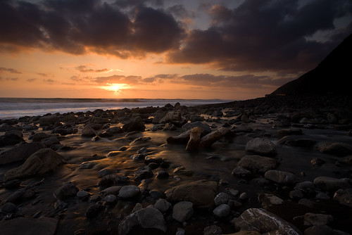
We arrived at Cooskie creek and setup camp well before sundown. This gave us plenty of time to relax, drink some Vodka and Gatorade mix, and wait until the sun was more agreeable for photos. I cooked up a backpacker meal of Kung Pao Chicken, but was rather disappointed with it. It's definitely not one I would recommend. Being well fed and slightly buzzed we headed down to where the creek met the sea and took some photographs while the light was good. The evening finished off with a roaring fire, some more vodka, and a few long exposure shots with the cameras.
A map of the trip with waypoints and photos can be found here.
View Rob's take on the day here: http://www.momsaysimrunningaway.com/blog/the-lost-coast.html
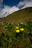
A few more shots from the day:


5 comments:
Looking forward to the rest of your trip. Heading there in 4 weeks and this is the most current review I've found so far. And you're a photographer--which always keeps me interested!
wow! the main picture reminds me of Scotland or something!
cool stuff Randy!
@Mark - It's a really great trip, especially if you take care of you're feet. I wish I had been feeling more motivated to go out and take more photos along the way, but all the same I'm glad I went and I would definitely do it again.
@Felicia - Thanks :-)
I came across your blog while gathering info for a planned summer hike of this trail. It is very inspiring and I love the pictures. I too, plan to capture the beauty "on film." Any tips for a fellow shutterbug?
Thanks!
Albert
Hi Albert. It's an amazing hike, and I'm sure you'll have a great time.
As for photography tips, the pieces of gear I found most useful were a polarizer and a 3-stop Neutral Density filter.
It's also a must to have a tripod to get the smoothed out water from long exposures around sunset. I bring the lightest one I can that is stable enough to get the job done (of course if the wind is howling then you're probably out of luck either way). I had an old 2.5 pound plastic tripod that I took on my two trips there that worked "good enough". Recently I bought a super light weight carbon fiber tripod which I suspect will work even better next time.
For lenses, I carry a wide angle (17-40), single prime (50mm or 85mm...I chose 85 on this trip and 50 on the one I did this year). I also lugged around a 70-200 F/4 lens this year, but it was a lot of weight for how little I used it.
Other than that, take advantage of that golden light hour around sunset and just have a good time :-)
Post a Comment